An Introduction to LiDAR Simulation with HELIOS++
III: Evaluate AFwizard-based ground filtering with HELIOS++
LiDAR simulation can be useful for multiple applications:
- Acquisition planning
- Method development and evaluation
- Training data generation (for machine learning)
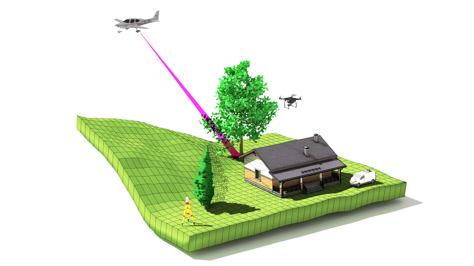
In this notebook, we will use HELIOS++ for method evaluation, i.e., to assess the groundfiltering results of AFwizard with virtual "ground truth".
We have prepared an ALS scenario for virtual simulation over the 2nd study site (Monastery St. Anna & Scharfeneck Ruin, AT). We will run the simulation, which will give us a point cloud with a ground truth classification of terrain and vegetation. We can then run AFwizard with the pipeline we built before and compare the AFwizard classification with our "virtual ground truth" to evaluate the suitability of our pipeline. As such, we do not have to rely on visual expert assessment for judging our filtering pipeline but can actually quantify the filtering quality.
# Imports
from pathlib import Path
import matplotlib.pyplot as plt
import matplotlib
import pyhelios
from pyhelios import SimulationBuilder
from pyhelios.util import flight_planner
import helper_funcs
import numpy as np
import laspy
import scipy.spatial
To execute LAStools commands, we need to provide the LAStools directory. This may be a different location on your computer, so you will have to provide the correct path:
# configure LAStools root
lastools_root = "C:/LAStools"
1. Running the simulation
Preparing the scene part files
We first have to create a few files which we need as input to our simulation, namely:
- the terrain (as .tif GeoTIFF)
- the vegetation cover (as .xyz ASCII), which HELIOS++ will internally transform into a voxel model
# making sure that data/output exists before execution
Path("data/output").mkdir(parents=True, exist_ok=True)
# extracting vegetation points using LAStools and write as XYZ ASCII (text) file
!$lastools_root/bin/las2txt64.exe -i data/StA_last.laz -o data/output/StA_last_vegetation.xyz -keep_classification 0 -parse xyz
Writing the scene
HELIOS++ uses XML files for configuring scanners, platforms, surveys and scenes. Below, we write such an XML file and fill in the values we defined before (terrain, vegetation, voxel_size). Note how each scene part is embedded in a <part> tag and uses a different "loader" filter depending on the file format.
terrain = "data/StA_last_dtm.tiff"
vegetation = "data/output/StA_last_vegetation.xyz"
voxel_size = 0.5
# Writing the scene XML file
scene_content = f"""<?xml version="1.0" encoding="UTF-8"?>
<document>
    <scene id="helios_scene" name="HELIOS scene">

        <part>
            <filter type="geotiffloader">
                <param type="string" key="filepath" value="{terrain}" />
            </filter>
        </part>
        <part>
            <filter type="xyzloader">
                <param type="string" key="filepath" value="{vegetation}" />
                <param type="string" key="separator" value=" " />
                <param type="double" key="voxelSize" value="{voxel_size}" />
            </filter>
        </part>
    </scene>
</document>
"""
# save scene file to the current directory
scene_file = "StA_helios_scene.xml"
with open(scene_file, "w") as f:
    f.write(scene_content)
Writing the survey
A pre-defined survey with all relevant parameters is given below. We only enter the scene file from our Python variable.
from pyhelios.util import flight_planner
bbox = [19800, 312150, 20600, 312900]
waypoints, centre, distance = flight_planner.compute_flight_lines(bounding_box=bbox,
                                               spacing=260,
                                               rotate_deg=-10,
                                               flight_pattern="parallel")
# add slight random noise to each waypoint, so they are not perfectly parallel
pos_noise = np.random.uniform(-10, 10, waypoints.shape)
waypoints += pos_noise
dtm, tf, bounds, origin_left, origin_bottom, origin_right, origin_top = helper_funcs.read_raster(terrain)
plt.imshow(dtm, cmap="terrain", extent=[origin_left, origin_right, origin_bottom, origin_top])
plt.plot(waypoints[:, 0], waypoints[:, 1])
plt.show()

legs = flight_planner.write_legs(waypoints, altitude=1288, template_id="scanner_als", speed="50")
# insert scene XML string and writing part below; see below as template
survey_content = f'''<?xml version="1.0" encoding="UTF-8"?>
<document>
    <platformSettings id="platform_als" movePerSec_m="50" />
    <scannerSettings active="true" id="scanner_als" pulseFreq_hz="100000" scanAngle_deg="45" scanFreq_hz="60" trajectoryTimeInterval_s="0.01"/>
    <survey name="als_survey_StA" platform="data/platforms.xml#sr22" scanner="data/scanners_als.xml#riegl_lms-q560" scene="{scene_file}#helios_scene">
    <FWFSettings beamSampleQuality="5" winSize_ns="1.5"/>
    {legs}
    </survey>
</document>
'''
survey_file = "als_survey_StA.xml"
with open(survey_file, 'w') as f:
    f.write(survey_content)
Executing HELIOS++
Now we are all set to execute HELIOS++. Since AFwizard takes a LAZ file as input, we run HELIOS++ in command line mode (rather than using the Python bindings) and then work with the written LAZ files.
!helios $survey_file --lasOutput --zipOutput --output helios_output -q
3. Running the AFwizard pipeline
HELIOS++ writes one file per flight line ("leg"). We first merge the flight lines to a single LAZ file and then use this LAZ file as input to AFwizard. We furthermore extract the simulated ground points by selecting the points with "hitObjectId" = 0. These will serve as our reference for AFwizard.
outfolder = helper_funcs.find_playback_dir(survey_file, output_folder="helios_output")
!$lastools_root/bin/lasmerge64.exe -i $outfolder/*.laz -o data/output/helios_als_StA.laz -faf
!$lastools_root/bin/lasinfo64.exe data/output/helios_als_StA.laz
lasinfo (220107) report for 'data/output/helios_als_StA.laz'
reporting all LAS header entries:
  file signature:             'LASF'
  file source ID:             0
  global_encoding:            0
  project ID GUID data 1-4:   00000000-0000-0000-0000-000000000000
  version major.minor:        1.4
  system identifier:          'LAStools (c) by rapidlasso GmbH'
  generating software:        'lasmerge64 (version 220107)'
  file creation day/year:     301/2025
  header size:                375
  offset to point data:       1197
  number var. length records: 1
  point data format:          6
  point data record length:   74
  number of point records:    0
  number of points by return: 0 0 0 0 0
  scale factor x y z:         0.0001 0.0001 0.0001
  offset x y z:               20199.873999999999796 312525.01500000001397 296.580997741699207
  min x y z:                  19799.3195 312149.6091 238.2840
  max x y z:                  20600.4089 312900.4420 354.9931
  start of waveform data packet record: 0
  start of first extended variable length record: 0
  number of extended_variable length records: 0
  extended number of point records: 3902605
  extended number of points by return: 1714247 1237603 624244 238340 69379 15541 2768 423 55 5 0 0 0 0 0
variable length header record 1 of 1:
  reserved             0
  user ID              'LASF_Spec'
  record ID            4
  length after header  768
  description          'by LAStools of rapidlasso GmbH'
    Extra Byte Descriptions
      data type: 10 (double), name "echo_width", description: "Helios++ echo width", scale: 1 (not set), offset: 0 (not set)
      data type: 6 (long), name "fullwaveIndex", description: "Helios++ fullwave index", scale: 1 (not set), offset: 0 (not set)
      data type: 6 (long), name "hitObjectId", description: "Helios++ hit object ID", scale: 1 (not set), offset: 0 (not set)
      data type: 10 (double), name "heliosAmplitude", description: "Helios++ Amplitude", scale: 1 (not set), offset: 0 (not set)
LASzip compression (version 3.4r3 c3 50000): POINT14 3 BYTE14 3
reporting minimum and maximum for all LAS point record entries ...
  X            -4005545    4005349
  Y            -3754059    3754270
  Z             -582970     584121
  intensity           0         67
  return_number       1          7
  number_of_returns   1          7
  edge_of_flight_line 0          0
  scan_direction_flag 0          0
  classification      0          0
  scan_angle_rank     0          0
  user_data           0          0
  point_source_ID     1          3
  gps_time 300051.012500 300109.585430
  extended_return_number          1     10
  extended_number_of_returns      1     10
  extended_classification         0      0
  extended_scan_angle             0      0
  extended_scanner_channel        0      0
  attribute0          0          0  ('echo_width')
  attribute1        417 2.41133e+06  ('fullwaveIndex')
  attribute2          0          1  ('hitObjectId')
  attribute3    6.68315    1035.16  ('heliosAmplitude')
number of first returns:        1714247
number of intermediate returns: 950755
number of last returns:         1714247
number of single returns:       476644
overview over extended number of returns of given pulse: 476644 1226718 1157712 675844 269190 76638 16415 2944 450 50 0 0 0 0 0
histogram of classification of points:
         3902605  never classified (0)
In this LAStools window, we can see that the hitObjectId, which holds the information whether the point has been reflected from the ground (0) or from vegetation (1) is encoded in "attribute2". So on the following las2las commmand, we will drop all points with attribute 2 larger than 0 from the point cloud and write the result to a new file.
!$lastools_root/bin/las2las64.exe -i data/output/helios_als_StA.laz -o data/output/helios_als_StA_ground_gt.laz -drop_attribute_above 2 0
Now we run AFwizard on the unfiltered point cloud with our previously created filtering pipeline.
# run AFwizard on simulated point cloud
!afwizard --dataset=data/output/helios_als_StA.laz --dataset-crs=EPSG:31256 --segmentation=data/StA_segments_assigned.geojson --segmentation-crs=EPSG:31256 --output-dir=data/output --library filters --lastools-dir=$lastools_root
C:\Users\3DGeo\.local\share\mamba\envs\groundfiltering\Lib\site-packages\osgeo\gdal.py:311: FutureWarning: Neither gdal.UseExceptions() nor gdal.DontUseExceptions() has been explicitly called. In GDAL 4.0, exceptions will be enabled by default.
  warnings.warn(
We will find this point cloud in the output folder as helios_als_StA_filtered.las and will run a similar command on it, but this time using the classification value and keeping only the value 2.
!$lastools_root/bin/las2las64.exe -i data/output/helios_als_StA_filtered.las -o data/output/helios_als_StA_ground_afwizard.laz -keep_classification 2
4. Comparison of AFwizard output with ground truth
output_afwizard = "data/output/helios_als_StA_ground_afwizard.laz"
output_gt = "data/output/helios_als_StA_ground_gt.laz"
# read with laspy
las = laspy.read(output_afwizard)
pc_afwizard = np.array([las.x, las.y, las.z]).T
las = laspy.read(output_gt)
pc_gt = np.array([las.x, las.y, las.z]).T
# difference in number of points
diff = pc_gt.shape[0] - pc_afwizard.shape[0]
print(f"Difference in number of points: {diff} (= {diff/pc_gt.shape[0] * 100:.1f}%)")
Difference in number of points: 19590 (= 1.8%)
# calculate overlap ratio
def overlap_ratio(pc1, pc2, inlier_threshold=0.001):
    # get distance to closest point
    kdtree = scipy.spatial.KDTree(pc1)
    d, i = kdtree.query(pc2, k=1)
    # evaluate whether inlier or not
    inlier_count = np.sum(d < inlier_threshold)
    # compute overlap_ratio
    overlap_ratio = inlier_count / pc2.shape[0]

    outliers = pc2[d > inlier_threshold]

    return overlap_ratio, outliers
o_ratio, outliers = overlap_ratio(pc_afwizard, pc_gt, inlier_threshold=0.01)
print(f"Overlap ratio for threshold = 0.01: {o_ratio*100:.2f}%")
Overlap ratio for threshold = 0.01: 98.15%
# visualize side by side
fig, (ax1, ax2) = plt.subplots(nrows=1, ncols=2, figsize=(14, 7))

for pc, ax, title in zip([pc_gt, pc_afwizard], [ax1, ax2], ["Ground truth", "AFwizard"]):
    ax.scatter(pc[:, 0], pc[:, 1], c=pc[:, 2], s=0.02, cmap="terrain")
    ax.set_xlabel("X [m]")
    ax.set_ylabel("Y [m]")
    ax.axis('equal')
    ax.set_title(title)

ax2.scatter(outliers[:, 0], outliers[:, 1], c="black", s=0.05)
plt.tight_layout()
plt.show()

The black points on the right show which points were not correctly filtered by the AFwizard pipeline.